
High-Definition 3D Laser Scanning
Our high-definition 3D laser scanning service captures detailed, accurate, and comprehensive data of any physical space or object. This advanced technology enables us to create precise 3D models and digital representations that are essential for planning, design, and analysis.
-
Precision and Accuracy: Capture intricate details with millimeter precision.
-
Versatility: Suitable for a wide range of applications, from buildings and infrastructure to mechanical components.
-
Speed: Rapid data acquisition minimises downtime and project delays.


Aerial, Terrestrial, and Mobile Laser Scanning
Xpatial uses advanced aerial, terrestrial and mobile laser scanning technologies to capture accurate, high-quality 3D point clouds of built and natural environments.
Depending on the needs of each project, we select the right scanning method to capture buildings, infrastructure, roads, utilities, industrial sites, heritage assets, construction sites, forests, agricultural land, and mining environments.
Our laser scanning services support as-built documentation, Scan-to-BIM, Scan-to-CAD, asset management, condition assessment, design verification, construction monitoring, and digital twin development. By combining precise spatial data with geospatial intelligence, Xpatial helps clients better understand existing conditions, reduce site risks, improve project planning, and make confident data-driven decisions.
Mobile Laser Scanning
Xpatial provides advanced mobile laser scanning services for rapidly capturing highly accurate 3D spatial data across roads, rail corridors, utilities, buildings, industrial facilities, campuses, and large infrastructure networks.
Using state-of-the-art mobile mapping systems equipped with LiDAR, cameras, GNSS, and inertial navigation technologies, we efficiently collect dense point clouds and high-resolution imagery while on the move, significantly reducing field time compared to traditional surveying methods.
Mobile laser scanning is ideal for asset inventories, corridor mapping, road and rail surveys, digital twin development, infrastructure inspections, and GIS asset management. Xpatial delivers accurate, reliable, and scalable geospatial data that helps organisations improve planning, reduce project risks, and make better decisions through spatial intelligence.

Scan to BIM
Our Laser Scanning services provide Building Information Modeling (BIM). We convert scanned data into BIM models, enhancing collaboration, reducing errors, and improving project outcomes.
-
Seamless Integration: Convert point cloud data into BIM-compatible formats (e.g. Revit or IFC).
-
Improved Collaboration: Enhance communication and coordination among project stakeholders.
-
Cost Savings: Reduce rework and project costs through accurate, up-to-date information.
Scan to CAD
Xpatial provides professional Scan-to-CAD services that convert laser scans and point cloud data into accurate 2D CAD drawings and as-built documentation.
Our team produces floor plans, elevations, sections, site plans, and detailed engineering drawings for buildings, infrastructure, industrial facilities, and asset management projects. Scan-to-CAD provides a reliable digital record of existing conditions, supporting design, renovation, construction, and facility management workflows while reducing the need for costly site rework and manual measurements.


Point Cloud
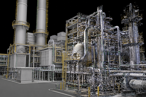
Point cloud data is a collection of millions of points captured by our advanced laser scanning technology, representing surfaces or objects. This data forms the foundation for creating highly accurate and detailed digital models, allowing for precise measurement, analysis, and visualization. Point clouds provide a comprehensive and reliable basis for various applications, including 3D modeling, BIM integration, and as-built documentation. By leveraging point cloud data, we ensure that every project benefits from enhanced accuracy, reduced errors, and improved efficiency, delivering results that meet the highest standards of quality and precision.
Industrial Applications
For industrial clients, we offer Laser Scanning services tailored to meet the rigorous demands of manufacturing, maintenance, and quality control. Our precise measurements and detailed models ensure that your operations run smoothly and efficiently.
-
Equipment and Facility Scanning: Detailed scans of machinery and industrial facilities.
-
Quality Control: Ensure components meet exact specifications.
-
Maintenance Planning: Facilitate effective maintenance and upgrades.


